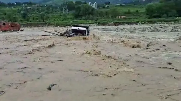


The recent cloudburst disasters should serve as a wake-up call for adopting a new development paradigm in the Himalayas. Citizens must recognise that rivers, streams, wetlands and floodplains are not vacant land awaiting development but essential components of Kashmir’s natural safety system. Preventing encroachments, protecting forests and wetlands, and maintaining local drainage channels are shared responsibilities. The mountains are sending increasingly frequent warnings—whether these hazards become disasters depends largely on the choices we make today.
Pir Rayees Ahmad
Cloudbursts have become an increasingly alarming reminder of the fragile nature of the Himalayan environment. The recent cloudburst and cloudburst-like incidents across Kashmir have triggered flash floods, landslides, debris flows and riverbank erosion, claiming precious lives and causing extensive damage to homes, roads, bridges, orchards and public infrastructure. Seasonal streams that remain almost dry for much of the year transformed within minutes into raging torrents carrying boulders, mud and uprooted trees, leaving communities with little time to respond. These events reinforce an important reality: while cloudbursts are natural meteorological phenomena, disasters occur when extreme weather interacts with environmental degradation, unplanned development and inadequate preparedness. As climate change continues to reshape weather patterns across the Himalayas, the need to strengthen resilience against cloudbursts has never been greater.
Cloudbursts in a Changing Climate
A cloudburst is one of the most intense forms of localised rainfall. The India Meteorological Department (IMD) generally defines it as rainfall exceeding 100 millimetres within an hour over a relatively small geographical area. Such intense rainfall rapidly overwhelms streams, natural drainage channels and hill slopes, often resulting in flash floods and landslides within minutes. The Himalayan terrain provides ideal conditions for cloudburst formation. Moisture-laden winds from the Arabian Sea and the Bay of Bengal are forced to rise over steep mountain slopes through a process known as orographic lifting. As the air rises, it cools and condenses into towering cumulonimbus clouds capable of holding enormous quantities of moisture before releasing intense rainfall over a confined area. In Jammu and Kashmir, the interaction between western disturbances and the southwest monsoon frequently enhances these conditions, making the region particularly vulnerable to extreme rainfall events.
Scientific evidence indicates that climate change is increasing the likelihood of such events. The Himalayas are warming faster than the global average, and a warmer atmosphere can hold nearly seven per cent more moisture for every one-degree Celsius increase in temperature. Assessments by the Intergovernmental Panel on Climate Change (IPCC), the India Meteorological Department (IMD) and the Indian Institute of Tropical Meteorology (IITM) indicate that while annual rainfall may not increase substantially, rainfall is becoming increasingly erratic and concentrated into short-duration, high-intensity events. Although no single cloudburst can be directly attributed to climate change, rising temperatures are creating atmospheric conditions that favour more frequent and intense rainfall across the western Himalayas.
Understanding the Growing Risk of Cloudbursts
Cloudbursts are natural hazards, but the extent of destruction they cause is largely influenced by human activities. Rapid urbanisation, indiscriminate construction, hill cutting, quarrying, deforestation and encroachments upon floodplains, wetlands and seasonal streams have significantly increased the exposure of people and infrastructure to flash floods and landslides.
From a hydrogeological perspective, Kashmir is traversed by numerous first- and second-order streams, locally known as nallahs. Many of these remain dry or carry very little water for most of the year, creating a false perception that they are safe for construction. As a result, roads, residential colonies, hotels and commercial establishments have increasingly occupied these natural drainage corridors. During cloudbursts, however, these channels transform within minutes into powerful torrents carrying water, sediments, boulders and woody debris. Many drainage channels have also been narrowed or obstructed by encroachments and indiscriminate dumping of excavated material, further reducing their carrying capacity. Nature invariably reclaims these pathways during extreme rainfall, often with devastating consequences.
Environmental degradation has further amplified disaster risk. Forests intercept rainfall, stabilise slopes through their root systems and promote groundwater recharge, while wetlands act as natural flood buffers by temporarily storing excess runoff and releasing it gradually. Their degradation has reduced the Valley’s natural ability to moderate floodwaters. Similarly, indiscriminate hill cutting and poorly engineered road construction destabilise slopes and increase the likelihood of landslides and debris flows.
The economic impacts are equally severe. Roads, bridges, irrigation canals, drinking water schemes, schools, hospitals, hydropower projects, orchards and agricultural land frequently suffer extensive damage. Tourism, one of Kashmir’s major economic drivers, is repeatedly disrupted due to damaged infrastructure and unsafe travel conditions. The recurring costs of reconstruction place a significant financial burden on governments while affecting the livelihoods of thousands of families.
Towards A Cloudburst-Resilient Kashmir
Cloudbursts cannot be prevented, but their impacts can be substantially reduced through scientific planning, stronger institutions and active community participation. The emphasis must shift from post-disaster relief to proactive disaster risk reduction.
Scientific land-use planning should become the cornerstone of future development. Hazard zonation maps prepared using Geographic Information Systems (GIS), remote sensing, LiDAR, drone surveys and hydrological modelling should guide the planning of roads, bridges, schools, hospitals, tourism infrastructure and residential colonies. Construction within floodplains, seasonal stream corridors and landslide-prone slopes must be strictly regulated through effective enforcement of planning laws and environmental safeguards. Every major infrastructure project in mountainous terrain should be preceded by comprehensive geological, hydrogeological and environmental assessments.
Nature-based solutions offer one of the most effective and sustainable approaches to reducing cloudburst impacts. Large-scale afforestation, watershed treatment, wetland conservation, spring rejuvenation, soil conservation, slope stabilization, rainwater harvesting and groundwater recharge should become integral components of climate adaptation programmes. Restoring degraded catchments is often more economical than repeatedly rebuilding damaged infrastructure after every disaster.
Forecasting and last-mile dissemination of warnings require equal attention. The India Meteorological Department has significantly strengthened weather forecasting through Doppler Weather Radars, satellite observations, automatic weather stations and advanced numerical weather prediction models. However, accurate forecasts are useful only when timely warnings reach vulnerable communities. Installation of automatic rain gauges, stream-level monitoring stations and community-based early warning systems in vulnerable catchments can provide valuable lead time for evacuation. Mobile alerts, village volunteers, public address systems, regular mock drills and village-level disaster management plans should become integral components of preparedness.
Infrastructure itself must also become climate resilient. Roads, bridges, culverts, retaining walls and drainage systems should be designed using projected future rainfall rather than historical averages alone. Adequate cross-drainage structures, bioengineering techniques for slope stabilization, proper disposal of excavated material during road construction and regular maintenance of drainage channels can substantially reduce disaster losses.
Government agencies already possess significant technical expertise. The India Meteorological Department (IMD), National Disaster Management Authority (NDMA), State Disaster Management Authority (SDMA), Central Water Commission (CWC), Central Ground Water Board (CGWB), Geological Survey of India (GSI), Forest Department, Irrigation & Flood Control Department, Rural Development Department and Urban Local Bodies all play complementary roles in weather forecasting, flood monitoring, groundwater studies, hazard mapping, watershed management and disaster preparedness. The implementation of integrated watershed management, catchment treatment, landslide risk reduction and floodplain management programmes should be accelerated through better coordination and data sharing among these agencies.
No disaster management strategy can succeed without active community participation. Citizens must recognise that rivers, streams, wetlands and floodplains are not vacant land awaiting development but essential components of Kashmir’s natural safety system. Preventing encroachments, protecting forests and wetlands, maintaining local drainage channels, promoting rainwater harvesting and participating in afforestation and awareness programmes are shared responsibilities. Disaster preparedness should become an integral part of school education, Panchayat planning and urban governance so that communities know how to respond effectively when warnings are issued.
The recent cloudburst disasters should serve as a wake-up call for adopting a new development paradigm in the Himalayas. The mountains are sending increasingly frequent warnings through cloudbursts, flash floods and landslides. Whether these hazards become disasters depends largely on the choices we make today. Scientific planning, resilient infrastructure, healthy watersheds, effective governance and informed communities must become the pillars of future disaster management. Investing in resilience today is far less costly than rebuilding after every disaster. Protecting rivers, streams, forests and wetlands is not merely an environmental responsibility; it is an investment in the safety, water security and sustainable future of generations to come.
The writer is a Senior Scientist (Hydrogeologist), Central Ground Water Board, Ministry of Jal Shakti, Government of India
ra***********@*ov.in